AAU Herbarium Database |
| New Search Modify Search |
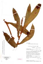
| Type of: | Columnea nematoloba L.P. Kvist & L.E. Skog |
| Collector | Croat, T.B. |
| Number | 61310 |
| Collected with | |
| Country | Colombia |
| Subpart | |
| County | |
| Locality | Valle del Cauca: Buenaventura Municipio Bajo Calima, within Forestry Concession of Carton de Colombia, between Buenaventura & Rio Calima, 6.3 km north og Frente La Brea, km 18 on main road, about 6 km southeast of village of san Isidro on rio Calima; primary forest |
| Coordinates | 40° 2' N 77° 3' W |
| Minimum elevation (m) | 50 |
| Maximum elevation (m) | 50 |
| Start date | 1986/07/07 |
| End date | 1986/07/07 |
| Family | Gesneriaceae |
| Identification | Columnea nematoloba L.P. Kvist & L.E. Skog |
| Determined by | |
| Identification qualifier | |
| Field notes | Epiphyte; Blades maroon-spotted toward the tip; Calyx yellow-green; Corolla orange. |
| |
| New Search Modify Search |