AAU Herbarium Database |
| New Search Modify Search |
| Collector | Young, S.M. |
| Number | 25 |
| Collected with | |
| Country | |
| Subpart | |
| County | |
| Locality | South shore of the Aguarico River near Zancudo Lade. By the bank of the river in a pasture. |
| Coordinates | |
| Minimum elevation (m) | 300 |
| Maximum elevation (m) | 300 |
| Start date | 1979/08/29 |
| End date | 1979/08/29 |
| Family | Poaceae |
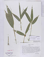
| Identification | Guadua angustifolia Kunth |
| Determined by | L.G. Klark (ISC) |
| Identification qualifier | |
| Field notes | Clump semi-open, about 7m in diam., many culms having been cut. Rhizome determinate. Culms 20m tall and 9cm in diam., erect at base with nodding; tips. Internodes glabrous, sulcate above buds and branches for half the length, hollow. Nodes not at all inflated, nodal ridge absent, all gemmiferous with central 4 or 5 not developing into branches white lanate band on both sides. Foliage dark green. .New culms dark green and pubescent, older ones turning light brown and becoming covered with lichens. Sterile. |

| |
| This record has no coordinates. Display map with the 3 georeferenced records of Guadua angustifolia in the AAU Herbarium Database. |
| New Search Modify Search |