AAU Herbarium Database |
| New Search Modify Search |
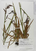
| Collector | Laegaard, S. |
| Number | 51860 |
| Collected with | |
| Country | Ecuador |
| Subpart | COTOPAXI |
| County | |
| Locality | Volcán Cotopaxi. Along the road to and at Limpio Punga. |
| Coordinates | 0° 37' S 78° 27' W |
| Minimum elevation (m) | 3500 |
| Maximum elevation (m) | 3850 |
| Start date | 1984/03/23 |
| End date | 1984/03/23 |
| Family | Juncaceae |
| Identification | Luzula ecuadoriensis Balslev |
| Determined by | Balslev, H., 1986. |
| Identification qualifier | |
| Field notes | Dry riverbed. 3500 m. |
| |
 Other records of Luzula ecuadoriensis Other records of Luzula ecuadoriensisThe map displays only records from the Aarhus Herbarium Database. The records may not represent the full distribution of Luzula ecuadoriensis |
| New Search Modify Search |