AAU Herbarium Database |
| New Search Modify Search |
| Collector | Laegaard, S. |
| Number | 18942 |
| Collected with | |
| Country | Ecuador |
| Subpart | LOJA |
| County | |
| Locality | Along main road 1-5 km N of entrance to Refugio Carboncillo. |
| Coordinates | 3° 33' S 79° 15' |
| Minimum elevation (m) | 2900 |
| Maximum elevation (m) | 2900 |
| Start date | 1998/06/26 |
| End date | 1998/06/26 |
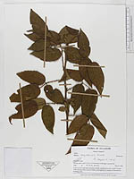
| Family | Rosaceae |
| Identification | Rubus bogotensis Kunth |
| Determined by | S. Laegaard |
| Identification qualifier | |
| Field notes | In dry scrub- and grass-páramo, mostly regularly burned. Small clumps with erect growth, most probably propagating by means of horizontal, budding roots. |
| |
 Other records of Rubus bogotensis Other records of Rubus bogotensisThe map displays only records from the Aarhus Herbarium Database. The records may not represent the full distribution of Rubus bogotensis |
| New Search Modify Search |