AAU Herbarium Database |
| New Search Modify Search |
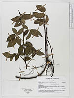
| Collector | Laegaard, S. |
| Number | 18694 |
| Collected with | |
| Country | Ecuador |
| Subpart | LOJA |
| County | |
| Locality | Along road Ona-Saraguro ca 5 km N of Carboncillo. Dry shrub-paramo with open grass areas |
| Coordinates | 3° 30' S 79° 10' |
| Minimum elevation (m) | 2850 |
| Maximum elevation (m) | 2850 |
| Start date | 1998/04/11 |
| End date | 1998/04/11 |
| Family | Rosaceae |
| Identification | Rubus bogotensis Kunth |
| Determined by | S. Laegaard |
| Identification qualifier | |
| Field notes | Propagating by long root-runners, clone distributed over app. 100 sqm in frequently burned paamo. Only seen sterile. |
| |
 Other records of Rubus bogotensis Other records of Rubus bogotensisThe map displays only records from the Aarhus Herbarium Database. The records may not represent the full distribution of Rubus bogotensis |
| New Search Modify Search |