AAU Herbarium Database |
| New Search Modify Search |
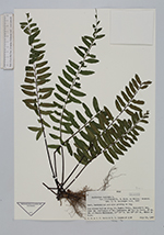
| Collector | Smith, S.F. |
| Number | 1108 |
| Collected with | C.C.Smith, M.A.Condon |
| Country | Peru |
| Subpart | |
| County | |
| Locality | Dry stream bottom along the bamboo trail, explorer's Inn, near the confluence of Río Tambopata and Río La Torre, 39 km. SW of Puerto Maldonado, Madre de Dios. |
| Coordinates | 12° 50' S 69° 20' W |
| Minimum elevation (m) | 0 |
| Maximum elevation (m) | 0 |
| Start date | 1987/07/19 |
| End date | 1987/07/19 |
| Family | Aspleniaceae |
| Identification | Asplenium cirrhatum Rich. |
| Determined by | |
| Identification qualifier | |
| Field notes | Herb, terrestial and also growing on log. |
| |
 Other records of Asplenium cirrhatum Other records of Asplenium cirrhatumThe map displays only records from the Aarhus Herbarium Database. The records may not represent the full distribution of Asplenium cirrhatum |
| New Search Modify Search |