| Collector | Barrow, S. |
| Number | 122 |
| Collected with | Baker,W.,Maturbongs,R., Wanggai.J., Sagisolo,M., Rustiami,H. & Wutoi,O.G. |
| Country | Papua New Guinea |
| Subpart | |
| County | |
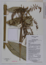
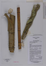
| Locality | Wandammen Peninsula, Wasior District, Manokwari Regency; near Dotir village, 11 km north of Wasior, near the confluence of the Mawoi River and the Yois River. Ridge above lowland forest and river. C. hollrungii common throughout ridge locality |
| Coordinates | 2° 37' 50.3'' S 134° 29' 54.9'' e |
| Minimum elevation (m) | 50 |
| Maximum elevation (m) | 50 |
| Start date | 2000/02/20 |
| End date | 2000/02/20 |
| Family | Arecaceae |
| Identification | Calamus aruensis Becc. |
| Determined by | A. Henderson |
| Identification qualifier | |
| Field notes | Climbing palm to 15m, with c. 15m of loose cane at ground level; internodes 30cm; leaves 4-5m long including petiole 4cm and cirrus 1.5-2m; leaflets 2 x 13, to 10cm x 40cm; male inflorescences; yellowgreen, with 8 partial inflorescences, branching to 3 orders, prophyll 30cm long, rachis bract 25-30cm long, immature flowers yellow-green. General purpose cane with multiple uses (tying, woven baskets etc.)Vernacular: Apo Gui Dialect: Bahasa Wamesa� |
|
 Other records of Calamus aruensis