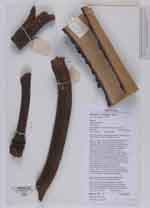
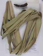
| Field notes | Solitary, single-stemmed, dioecious palm with stem to 19m tall. Stem 137cm circumference at base, widening to 213cm at 9.1 m height. Stem grey with indistinct leaf scars, partially obscured by fire and lichens. Crown of 18 green leaves, including 3 unexpanded leaves in the sword. Leaves costapalmate, costa between 143cm and 148cm long. Petiole dark brown to yellow-green, armed with recurved black spines, and between 137cm and 167cm long. Lamina divided to between 63cm and 76cm, with between 97 and 102 leaflets. Shortest leaflet between 51 cm and 72cm long. Male tree with 3 newly-emergent inflorescences, and 6 inflorescences remaining from last year. Inflorescences to 134cm long and branching to 2 orders. Up to 3 empty bracts in each inflorescence. 1-3 rachillae on each rachis. Rachillae to 53cm long, and 4cm diameter. First flowers emerging. Specimens preserved using the Schweinfurth method, which may cause discolouration. Dead petioles burned as firewood. Generally considered a weed of agriculture, and frequently burned. Some specimens (particularly branched trees) are considered sacred in some communities. Vernacular: mvumo, Dialect: Swahili |
 Other records of Borassus aethiopum