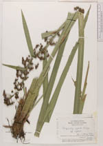
| Collector | Harley, R.M. |
| Number | 20171 |
| Collected with | et al. |
| Country | Brazil |
| Subpart | Bahia |
| County | |
| Locality | Estado Da Bahis. Serra Da Conquista ca. 12 km S.E. of Barra do Choqa on the road to Itapetinga. High “mata de cipó” forest, with mixed deciduous and evergreen trees and dense understory on deep loamy soil |
| Coordinates | 14° 57' S 40° 31' W |
| Minimum elevation (m) | 700 |
| Maximum elevation (m) | 700 |
| Start date | 1977/03/30 |
| End date | 1977/03/30 |
| Family | Cyperaceae |
| Identification | Becquerelia cymosa Brougn. |
| Determined by | S. Mayo |
| Identification qualifier | |
| Field notes | Tufted sedge. Leaves and lower bracts over 1 m. Leaf- and bract- sheaths brownish-purple. Glumes green |
|
 Other records of Becquerelia cymosa