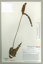
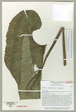
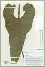
| Field notes | "Epiphyte; internodes short; cataphylls persistent as brown fibres; petioles 30-80 cm long, terete, sulcate adaxially; geniculum ca. 2 cm long, often red; lamina cordate with large basal lobes; midrib V-shaped on lower surface, midrib & basal veins raised above, prim. & sec. lateral veins sunken above, raised below; midrib & prominent veins light green, tertiary veins visible against light; basal ribs meeting at 180°, sinus hippocrepiform to parabolic; upper surface dark green, matt, lower surface lighter green, matt; collective vein close to margin; peduncle half as long as petiole, terete; spathe broadly ovate to boat shaped, light green to whitish, striated, erect, directed at 90° angle to peduncle, hooding the spadix, accuminate; stipe 5-8 mm long, bulged at base & apex; spadix green, tapered, pendent." |
 Other records of Anthurium obpyriforme