AAU Herbarium Database |
| New Search Modify Search |
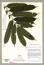
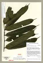
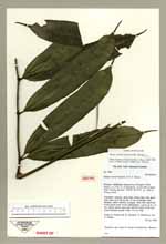
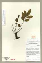
| Type of: | Danaea erecta Tuomisto & R.C.Moran |
| Collector | Moran, R.C. |
| Number | 5950 |
| Collected with | et al. |
| Country | Ecuador |
| Subpart | Pichincha |
| County | |
| Locality | Maquipucuna Biological Field Station, ca. 5 km E of Nanegalito, 34 km NW of Quito, Trail “Camino del Rio”. Primary forest |
| Coordinates | 0° 8' N 78° 37' W |
| Minimum elevation (m) | 1300 |
| Maximum elevation (m) | 1300 |
| Start date | 1996/04/04 |
| End date | 1996/04/04 |
| Family | Marattiaceae |
| Identification | Danaea erecta Tuomisto & R.C.Moran |
| Determined by | |
| Identification qualifier | |
| Field notes | Terrestrial; common, stem erect, leaves often with apical buds, stem up to 80 cm tall, 15 cm in diameter (incl. stipules), leaves radically arranged, when stem appressed to soil grows roots on the undersurface. Leaves up to 2 m tall, petiole clearly more than half the lenght of the leaf. Leaves become pinnate when < 10 cm long |
| |
 Other records of Danaea erecta Other records of Danaea erectaThe map displays only records from the Aarhus Herbarium Database. The records may not represent the full distribution of Danaea erecta |
| New Search Modify Search |