| Collector | Bernal, R. |
| Number | 4547 |
| Collected with | H. Balslev, G. Galeano, L. Mesa, D. Pedersen, J.C. Garcés, F.J. Horacio, N. Morueta, L. Skov Jensen, A. Gaitan and R. Gaitan |
| Country | Colombia |
| Subpart | Guainía |
| County | |
| Locality | Río Guaviare S bank, 2 km NE of Murciélago, approximately 600 m inland to the SE across Theobroma cacao stand and a small field, 185 km W of Inírida. Tropical rain forest on flood plain; canopy 20-30 m tall, many tangles in understory. |
| Coordinates | 3° 35' 10.8'' N 69° 34' 36.8'' W |
| Minimum elevation (m) | 128 |
| Maximum elevation (m) | 0 |
| Start date | 2009/09/26 |
| End date | 0/00/00 |
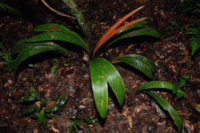
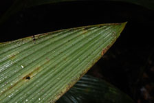
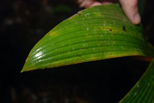
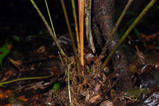
| Family | Arecaceae |
| Identification | Geonoma macrostachys var. macrostachys Mart. |
| Determined by | R. Bernal & H. Balslev |
| Identification qualifier | |
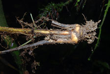
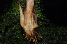
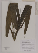
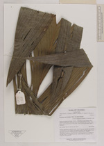
| Field notes | Soliatary, acaulescent, understory palm. Leaves 9 per stem; sheaths open; sheaths and petiole 69 cm long, round in cross section; rachis 84 cm long; pinnae 2-3 per side, basal pinna 81 cm, middle pinna 54 cm, apical pinna 41 cm long. Inflorescence interfoliar; peduncular bract 16 cm long; peduncle 21 cm long, 0.4 cm wide; rachis 12 cm long, 0.8 cm wide. Transect HB1027, subunit no. 013; UTM 19N-436168-395195. |


|