| Collector | Bernal, R. |
| Number | 4541 |
| Collected with | H. Balslev, G. Galeano, L. Mesa, D. Pedersen, J.C. Garcés, F.J. Horacio, N. Morueta, L. Skov Jensen, A. Gaitan and R. Gaitan |
| Country | Colombia |
| Subpart | Guainía |
| County | |
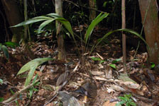
| Locality | Río Guaviare S bank, Barranco Picure, 5.6 km SW of Murciélago, approximately 2 km inland to the S across abandoned cattle pasture, 192 km WNW of Inírida. Tropical rain forest on low rolling terra firme hills; canopy 20-30 m tall, many thin stems. |
| Coordinates | 3° 32' 57.2'' N 69° 38' 5'' W |
| Minimum elevation (m) | 167 |
| Maximum elevation (m) | 0 |
| Start date | 2009/09/25 |
| End date | 0/00/00 |
| Family | Arecaceae |
| Identification | Geonoma macrostachys var. macrostachys Mart. |
| Determined by | R. Bernal & H. Balslev |
| Identification qualifier | |
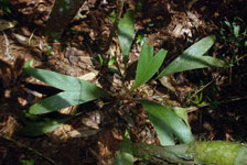
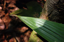
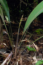
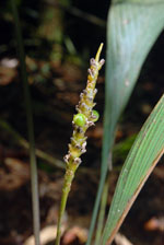
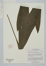
| Field notes | Solitary, understory palm. Leaves 7 per stem; sheaths open; sheaths and petiole 35 cm long, with margined cross section; rachis 30 cm long; lamina 49 cm long, 13.5 cm wide. Inflorescence interfoliar; prophyll 9.3 cm long, 1 cm wide, papery; peduncular bract 18.5 cm long, brown, papery; peduncle 33 cm long, 0.3 cm wide; rachis 7.5 cm long, 0.6 cm thick. Immature fruits green. Transect HB1025, outside subunit no. 049; UTM 19N-429504-392325. |
|