| Collector | Bernal, R. |
| Number | 4537 |
| Collected with | H. Balslev, L. Mesa, D. Pedersen, J.C. Garcés, F.J. Horacio, N. Morueta, L. Skov Jensen, A. Gaitan and R. Gaitan |
| Country | Colombia |
| Subpart | Guainía |
| County | |
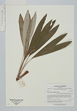
| Locality | Río Guaviare S bank, 4 km SSE of Murciélago, inland to the S across active and abandoned fields and into virgin forest; 183 km WSW of Inírida. Tropical rain forest on low rolling terra firme hills; canopy 20-30 m tall, many thin stems. |
| Coordinates | 3° 32' 12.9'' N 69° 34' 38.1'' W |
| Minimum elevation (m) | 170 |
| Maximum elevation (m) | 0 |
| Start date | 2009/09/23 |
| End date | 0/00/00 |
| Family | Arecaceae |
| Identification | Astrocaryum gynacanthum Mart. |
| Determined by | R. Bernal & H. Balslev |
| Identification qualifier | |
| Field notes | Seedling of understory palm. Leaves 3-6 per stem. Transect HB1022, collected outside the transect; UTM 19N-435888 -390961. |
|
 Other records of Astrocaryum gynacanthum