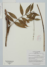
| Collector | Bernal, R. |
| Number | 4495 |
| Collected with | H. Balslev, L. Mesa, D. Pedersen, J.C. Garcés, F.J. Horacio, N. Morueta, L. Skov Jensen, E. Romero |
| Country | Colombia |
| Subpart | Guainía |
| County | |
| Locality | Río Guaviare N bank, Piedra Veradal, 9 km NE of Cumaral, 100 km WNW of Inírida. Tropical rainforest on floodplain, near large (20x40 m) rock sticking 15 m out of the ground. |
| Coordinates | 3° 44' 59.2'' N 68° 49' 40.4'' W |
| Minimum elevation (m) | 100 |
| Maximum elevation (m) | 0 |
| Start date | 2009/09/14 |
| End date | 0/00/00 |
| Family | Arecaceae |
| Identification | Desmoncus polyacanthos var. polyacanthos Mart. |
| Determined by | R. Bernal & H. Balslev |
| Identification qualifier | |
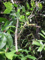
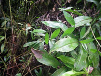
| Field notes | Cespitose, understory, liana palm. Stem aerial, 10 m long, 0.5 cm thick; internodes 18 cm long, > stem diameter, light brown, smooth but covered with spiny leaf sheaths. Leaves flat with 9 pinnae and 6 acanthophylls per side. Transect HB1012, subunit no. 098; UTM 19N-519110-414470. |

|
 Other records of Desmoncus polyacanthos var. polyacanthos