AAU Herbarium Database |
| New Search Modify Search |
| Collector | Maturbongs, R.A. |
| Number | 712 |
| Collected with | Edy Sambas & W. Takeuchi |
| Country | Indonesia |
| Subpart | West Papua |
| County | |
| Locality | Manokwari dist., Bintuni SubDist. Beside trail between saengga & Tanah Merah villages. Lowland forest, growing near the creeks to the edges of savanna. Sometimes found in the middle of savanna |
| Coordinates | |
| Minimum elevation (m) | 20 |
| Maximum elevation (m) | 20 |
| Start date | 2002/02/13 |
| End date | 2002/02/13 |
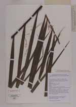
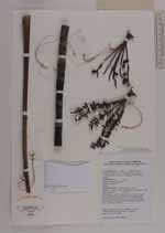
| Family | Arecaceae |
| Identification | Hydriastele |
| Determined by | |
| Identification qualifier | |
| Field notes | Small clustering palm, to 2 m tall. Trunk 20 mm in diam, nodes 5 cm long. Leaf to 100 cm long, petiole 30 cm long; leaflets 23 pcs on each side of rachis. Sheath green covered with brown indument. Inflorescence erect, 12 cm long, rachillae 6. Vernacular name: Sagarofa (Sumuri lang) |
| |
| This record has no coordinates. Display map with the 9 georeferenced records of Hydriastele in the AAU Herbarium Database. |
| New Search Modify Search |