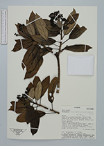
| Collector | Jorgensen, P. M. |
| Number | 1768 |
| Collected with | C.Ulloa, E.Narváez, S.Laegaard |
| Country | Ecuador |
| Subpart | Azuay |
| County | |
| Locality | Road Chiquintad-Labrado. North side ending at the dam Presa Chanlud, km 26.9. Disturbed upper Andean forest and grass páramo. |
| Coordinates | 2° 41' 54'' S 79° 1' 48'' W |
| Minimum elevation (m) | 3340 |
| Maximum elevation (m) | 3520 |
| Start date | 2000/01/09 |
| End date | 2000/01/09 |
| Family | Araliaceae |
| Identification | Oreopanax avicenniifolius (Kunth)Decne. & Planch. |
| Determined by | F.Borchsenius |
| Identification qualifier | |
| Field notes | Treelet 3 m. Underside of leaves covered with grayish tomentum. Fruits green turning black. |
|
 Other records of Oreopanax avicenniifolius