AAU Herbarium Database |
| New Search Modify Search |
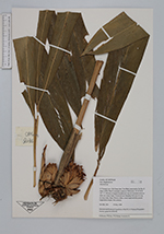
| Collector | Loc, P.K. |
| Number | CBL2031 |
| Collected with | P.H.Hoang, L.Averyanov |
| Country | Vietnam |
| Subpart | Ha Giang |
| County | |
| Locality | Distr. Yen Minh, municipality Du Gia, E slopes of Phu Tha Ca mountain system. Primary evergreen broadleaved very wet mountain forest on shale very steep slopes. |
| Coordinates | 23° 56' N 105° 13' E |
| Minimum elevation (m) | 1400 |
| Maximum elevation (m) | 1400 |
| Start date | 1999/05/03 |
| End date | 1999/05/03 |
| Family | Zingiberaceae |
| Identification | Amomum |
| Determined by | |
| Identification qualifier | |
| Field notes | Terrestial and lithophyte forb up to 2 m hg on steep rocky slope. Flowers white, central tepal with deep purple longitudinal stripes. Not common. |
| |
| Display all 79 georeferenced records of Amomum Amomum |
| New Search Modify Search |