| Collector | Maas, P.J.M. |
| Number | 7546 |
| Collected with | J.Koek-N., H.Lall, B.J.H. ter Welle, L.Y.Th. Westra |
| Country | Guyana |
| Subpart | |
| County | |
| Locality | Trail from abandoned balata bleeders camp at the base of Mt. Makarapan to Rupununi River. Mora forest |
| Coordinates | 3° 59' N 58° 57' W |
| Minimum elevation (m) | 0 |
| Maximum elevation (m) | 0 |
| Start date | 1988/09/19 |
| End date | 1988/09/19 |
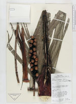
| Family | Arecaceae |
| Identification | Astrocaryum munbaca Mart. |
| Determined by | H.Balslev |
| Identification qualifier | |
| Field notes | Palm, ca. 3 m tall; stipe 1 m long; frond 2.5 m long, 1.5 m wide, with up to 35 pairs of pinnae; rachis covered with spines over the whole lenght on the lowerside. young fruit creamy, maturing dark orange |
|
 Other records of Astrocaryum munbaca