AAU Herbarium Database |
| New Search Modify Search |
| Collector | Barbour, P.J. |
| Number | 4860 |
| Collected with | |
| Country | Peru |
| Subpart | Madre de Dios |
| County | |
| Locality | Prov. Tambopata: ca. 30 air km or 70-80 river km SSW Puerto Maldonado at effluence Río La Torre (Río D'Orbigny)/ Río Tambopata (SE bank); Tambopata Nature Reserve; Tropical moist forest. |
| Coordinates | 12° 49' S 69° 17' W |
| Minimum elevation (m) | 260 |
| Maximum elevation (m) | 260 |
| Start date | 1980/04/19 |
| End date | 1980/04/19 |
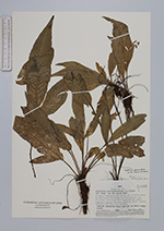
| Family | Aspleniaceae |
| Identification | Asplenium pearcei Baker |
| Determined by | R.C.Moran |
| Identification qualifier | |
| Field notes | Fertile epiphytic fern very low on small woody stems. |
| |
 Other records of Asplenium pearcei Other records of Asplenium pearceiThe map displays only records from the Aarhus Herbarium Database. The records may not represent the full distribution of Asplenium pearcei |
| New Search Modify Search |