| Collector | Berry, P.E. |
| Number | 158 |
| Collected with | |
| Country | Venezuela |
| Subpart | Zulia |
| County | |
| Locality | Distrito Oerija, Estado Zulia. Campamento Frontera VI. On tepui-like sandstone ridge 4x 0.5-1 km running E-W, east of the international border, between the headwaters of Rio del Norte and the southernmost branch of Rio Aricuaisa |
| Coordinates | 9° 30' N 73° 6' W |
| Minimum elevation (m) | 2400 |
| Maximum elevation (m) | 2400 |
| Start date | 1974/07/23 |
| End date | 1974/07/28 |
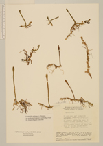
| Family | Lycopodiaceae |
| Identification | Pseudolycopodiella meridionalis (Underw. & F.E.Lloyd) Holub |
| Determined by | Kelsey Cook |
| Identification qualifier | |
| Field notes | In wet sand and alongside Spagnum; numerous tenacious white roots peg plant firmly to ground, below the moss at times; leaves lustrous coriaceous strobili upright, light yellow-green scales on axis, and tips of scales yellow-brown higher up on the strobilus |
|
 Other records of Pseudolycopodiella meridionalis