AAU Herbarium Database |
| New Search Modify Search |
| Collector | Bygrave, P.C. |
| Number | 20 |
| Collected with | et al. |
| Country | Brunei |
| Subpart | Temburong |
| County | |
| Locality | Amo. Bukit Tudal. 20 m from the ridge top NW from landing point down a steep, wide gulley. Ridge side. Lower montane forest, tall facies; dominants Lauraceae/Fagaceae/Myristicaceae. Brown hummus rich brown soil over Meligan formation Sandstone. |
| Coordinates | 4° 24' N 115° 18' E |
| Minimum elevation (m) | 840 |
| Maximum elevation (m) | 1160 |
| Start date | 1994/10/05 |
| End date | 1994/10/05 |
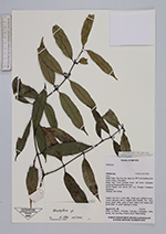
| Family | Rubiaceae |
| Identification | Urophyllum Wall. |
| Determined by | |
| Identification qualifier | |
| Field notes | Slender tree 5 m x 2.5 cm dbh. Trunk grey mottled brown. Leaves mid-green above, slightly paler beneath. Fls.; calyx gree; petals white, green at base; anthers and stigma pale green-white. Fr. green ripering to orange. |
| |
| Display all 41 georeferenced records of Urophyllum Urophyllum |
| New Search Modify Search |