AAU Herbarium Database |
| New Search Modify Search |
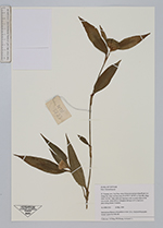
| Collector | Hiep, N.T. |
| Number | NTH2723 |
| Collected with | P.H. Huang, L. Averyanov |
| Country | Vietnam |
| Subpart | Lai Chau |
| County | |
| Locality | about 50 km downstream along Black river (Song Da), from Lai Chau town to Nam Ma village (distr. Sin Ho). Open shale and limestone rocks on steep slopes of the river. |
| Coordinates | 22° 3' N 103° 9' E |
| Minimum elevation (m) | 220 |
| Maximum elevation (m) | 220 |
| Start date | 1999/05/24 |
| End date | 1999/05/24 |
| Family | Commelinaceae |
| Identification | Commelinaceae |
| Determined by | |
| Identification qualifier | |
| Field notes | Lithophyte forb up to 0.5 m hg in wet place along steam. Common. |
| |
| Display all 105 georeferenced records of Commelinaceae |
| New Search Modify Search |