AAU Herbarium Database |
| New Search Modify Search |
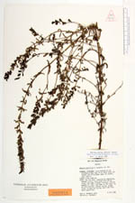
| Type of: | Bartsia patriciae N.H.Holmgren |
| Collector | Holmgren, N.H. |
| Number | 10072 |
| Collected with | P.K. Holmgren |
| Country | Ecuador |
| Subpart | Pichincha |
| County | |
| Locality | Santo Domingo de Los Colorados-Alóag road, 23 km above (east of) Tandapi and 18 km below (west of) summit. Common along roadside |
| Coordinates | |
| Minimum elevation (m) | 2510 |
| Maximum elevation (m) | 2510 |
| Start date | 1982/07/08 |
| End date | 1982/07/08 |
| Family | Scrophulariaceae |
| Identification | Bartsia mutica (Kunth)Benth. |
| Determined by | U.Molau/1987 |
| Identification qualifier | |
| Field notes | Stems long and weak, supported by vegetation, herbage viscid, calyx green with violet tinge, the lobes slightly reflexed, corolla magenta all over, the lobes of the lower lip bullate-involute, anthers yellow, stigma large, bilobed and yellow, style and filaments puberulent |
| |
| This record has no coordinates. Display map with the 8 georeferenced records of Bartsia mutica in the AAU Herbarium Database. |
| New Search Modify Search |