AAU Herbarium Database |
| New Search Modify Search |
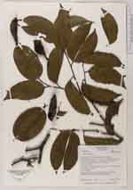
| Collector | Bass, M.S. |
| Number | 390 |
| Collected with | |
| Country | Ecuador |
| Subpart | Yasuni |
| County | |
| Locality | Yasuni Scientific Research Station. Rio Tiputini, northeast of its confluence with Rio Tivacuno; 6 km east of Maxus Road, km 44, off spur road to Tivacuno oilwell. Across driveway from Station garage. Terra firme; hills 30-50 m high, red clay soil. Forest 30-40 m tall with open canopy |
| Coordinates | 0° 38' S 76° 30' W |
| Minimum elevation (m) | 200 |
| Maximum elevation (m) | 300 |
| Start date | 1996/10/03 |
| End date | 1996/10/03 |
| Family | Fabaceae |
| Identification | Macrolobium |
| Determined by | |
| Identification qualifier | |
| Field notes | Tree of 25 m. Fruits already dehisced, fell from peduncle when touched. (fruits separate.) |
| |
 Other records of Macrolobium Other records of MacrolobiumThe map displays only records from the Aarhus Herbarium Database. The records may not represent the full distribution of Macrolobium |
| New Search Modify Search |