| Collector | Nee, M. |
| Number | 30246 |
| Collected with | J. Solomon |
| Country | Bolivia |
| Subpart | La Paz |
| County | |
| Locality | Along road from Coroico to Caranavi, canyon of Rio Coroico Just upstream from bridge to Suapi, 9 km by road N of Yolosa Slopes, the forest partly cleared |
| Coordinates | 16° 10' '' S 67° 43' 30'' W |
| Minimum elevation (m) | 1150 |
| Maximum elevation (m) | 1150 |
| Start date | 1984/10/30 |
| End date | 1984/10/30 |
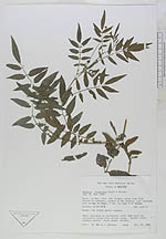
| Family | Solanaceae |
| Identification | Solanum suaveolens Kunth & Bouché |
| Determined by | Sandra Knapp & David M. Spooner |
| Identification qualifier | |
| Field notes | Herb, becoming an herbaceous vine Stem with two herbaceous wings from petiole bases Corolla white; anthers yellow. Fruit green, mottled |
|
 Other records of Solanum suaveolens