AAU Herbarium Database |
| New Search Modify Search |
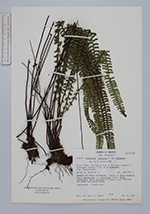
| Collector | Nee, M. |
| Number | 29104 |
| Collected with | K.Taylor |
| Country | Mexico |
| Subpart | Veracruz |
| County | |
| Locality | Cerro Verde, the tallest hill in the area, topped by microwave station, 1 km N of Carbonera. Mun. Huayacocotla. Bosque de Pinos-Oyameles. Forest of Abies religiosa, Pinus montezumae, P. ayacahuite (rare), Alnus jorullensis, Salix paradoxa on slopes, with clearings for maize and potato fields. |
| Coordinates | 20° 26' '' N 98° 28' 30'' W |
| Minimum elevation (m) | 2600 |
| Maximum elevation (m) | 2700 |
| Start date | 1984/01/27 |
| End date | 1984/01/27 |
| Family | Aspleniaceae |
| Identification | Asplenium monanthes L. |
| Determined by | R.G.Stolze |
| Identification qualifier | |
| Field notes | |
| |
| Display all 84 georeferenced records of Asplenium Asplenium monanthes |
| New Search Modify Search |