AAU Herbarium Database |
| New Search Modify Search |
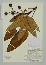
| Collector | Lewis, M. |
| Number | 39973 |
| Collected with | |
| Country | Bolivia |
| Subpart | La Paz |
| County | |
| Locality | Inquisivi Pro. "Río Jacha Kaihua". Upper partof the Río Jacha Kaihua, opposite side of headwaters of the Río Chekha. 1 km NW of Laguna Huara Huarani, 11 km NNW of Choquetanga. This is the ultimate patch of forest following the Quebrada up river, in a protected area between to rills and a cliff. The forest edge is mostly Weinmannia, with Baccharis and Miconia. Interior dominated by Hesperomeles, all laden with epiphytes. |
| Coordinates | 16° 45' S 67° 17' W |
| Minimum elevation (m) | 3750 |
| Maximum elevation (m) | 3820 |
| Start date | 1991/09/08 |
| End date | 1991/09/08 |
| Family | Araliaceae |
| Identification | Oreopanax macrocephalus Decne. & Planch. ex Wedd. |
| Determined by | |
| Identification qualifier | |
| Field notes | 4 m high shrub to 10 m high interior forest tree, always covered in dense epiphytes. Fruit green, pineapple like. |
| |
 Other records of Oreopanax macrocephalus Other records of Oreopanax macrocephalusThe map displays only records from the Aarhus Herbarium Database. The records may not represent the full distribution of Oreopanax macrocephalus |
| New Search Modify Search |