AAU Herbarium Database |
| New Search Modify Search |
| Collector | Lewis, M. |
| Number | 39362 |
| Collected with | V. Kuno |
| Country | Bolivia |
| Subpart | La Paz |
| County | |
| Locality | "Río Condor Khala" - - Along the Río Condor Khala whose mouth is 1 km down river from Aguas Calientes de Calachaca. Ca 2 km down river from Laguna Khasiri Pata, 9 km WNW of Choquetanga. This valley has an incredible condor-shaped mountain over looking it. Woodlands amongst massive boulder piles and ancient glacial terraces. |
| Coordinates | 16° 48' S 67° 25' W |
| Minimum elevation (m) | 3700 |
| Maximum elevation (m) | 3850 |
| Start date | 1991/07/19 |
| End date | 1991/07/19 |
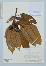
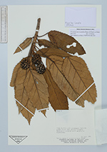
| Family | Araliaceae |
| Identification | Oreopanax macrocephalus Decne. & Planch. ex Wedd. |
| Determined by | A. Fuentes (LPB) |
| Identification qualifier | |
| Field notes | Tree to 5 m with pineapple looking green fruit and yellow flowers. Generally covered with epiphytic byophytes. |
| |
 Other records of Oreopanax macrocephalus Other records of Oreopanax macrocephalusThe map displays only records from the Aarhus Herbarium Database. The records may not represent the full distribution of Oreopanax macrocephalus |
| New Search Modify Search |