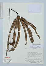
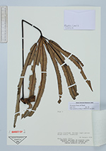
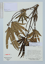
| Locality | Inquisivi. "Carabuco" - - Along the road between Choquetanga and Carabuco Power Station, and for 0.5 km north along the east bank of the Río Miguillas from the Carabuco Power Station. 1.0-2.5 km N of Choquetanga. Secondary growth woods, often burned, grazed or cut, along the river. "Carabuco" - - Along the road between Choquetanga and Carabuco Power Station, and for 0.5 km north along the east bank of the Río Miguillas from the Carabuco Power Station. 1.0-2.5 km N of Choquetanga. Secondary growth woods, often burned, grazed or cut, along the river. "Carabuco" - - Along the road between Choquetanga and Carabuco Power Station, and for 0.5 km north along the east bank of the Río Miguillas from the Carabuco Power Station. 1.0-2.5 km N of Choquetanga. Secondary growth woods, often burned, grazed or cut, along the river. "Carabuco" - - Along the road between Choquetanga and Carabuco Power Station, and for 0.5 km north along the east bank of the Río Miguillas from the Carabuco Power Station. 1.0-2.5 km N of Choquetanga. Secondary growth woods, often burned, grazed or cut, along the river. |