AAU Herbarium Database |
| New Search Modify Search |
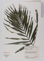
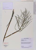
| Collector | Christenhusz, M.J.M. |
| Number | 5697 |
| Collected with | Maria Vorontsova, Jorge Jiménez Barrios & Kimberly Watson |
| Country | Guatemala |
| Subpart | Peten |
| County | |
| Locality | Flores. Parque Nacional Yxha-Nakum-Naranjo, northern shore of Laguna Yaxha and the surroundings of the archeological site Yaxjá, tropical forest on limestone |
| Coordinates | 17° 4' N 89° 23' W |
| Minimum elevation (m) | 200 |
| Maximum elevation (m) | 270 |
| Start date | 2009/03/14 |
| End date | 2009/03/14 |
| Family | Arecaceae |
| Identification | Chamaedorea |
| Determined by | |
| Identification qualifier | |
| Field notes | |
| |
 Other records of Chamaedorea Other records of ChamaedoreaThe map displays only records from the Aarhus Herbarium Database. The records may not represent the full distribution of Chamaedorea |
| New Search Modify Search |