AAU Herbarium Database |
| New Search Modify Search |
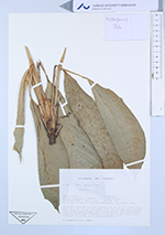
| Collector | Hagberg, M. |
| Number | 366 |
| Collected with | E-L. Medin |
| Country | Peru |
| Subpart | Loreto |
| County | |
| Locality | Maynas Prov. Puerto Almendras (CIEFOR). C.15km W Iquitos. Disturbed forest w. cleared understory over white sand. |
| Coordinates | 3° 48' S 73° 25' W |
| Minimum elevation (m) | 120 |
| Maximum elevation (m) | 120 |
| Start date | 1987/01/22 |
| End date | 1987/01/22 |
| Family | Marantaceae |
| Identification | Calathea |
| Determined by | |
| Identification qualifier | |
| Field notes | Rhizomes brenched to form clusters of up to c.15 basal lvs.. Each shootw. up to c.15 basal lvs., to c.0.5m total height. Leaf blades papyraceus, light green above, greyish beneath, somewhat scalloped. Pulvinus olive. All flower parts white. Frequent in forest w. cleared understory. |
| |
 Other records of Calathea Other records of CalatheaThe map displays only records from the Aarhus Herbarium Database. The records may not represent the full distribution of Calathea |
| New Search Modify Search |