AAU Herbarium Database |
| New Search Modify Search |
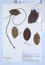
| Collector | Kvist, L.P. |
| Number | 984 |
| Collected with | L. Freitas A. |
| Country | Ecuador |
| Subpart | Loreto |
| County | |
| Locality | Lower Ucayali river, 6 km southwest of Jenaro Herrera village, "Zona de Supay", Curiyacu channal near the Sahua lake. Exposed somewhat disturbed vegetation along bank of channal. Flooded to several metres most of the year, predominantly with black water from local upland streams, occasionally with white water from the Ucayali river. |
| Coordinates | 4° 59' S 73° 43' W |
| Minimum elevation (m) | 120 |
| Maximum elevation (m) | 120 |
| Start date | 1994/02/07 |
| End date | 1994/02/07 |
| Family | Fabaceae |
| Identification | Dioclea |
| Determined by | Lars Peter Kvist, (RVAU) |
| Identification qualifier | |
| Field notes | Climbing, erect inflorescences with purple flowers. |
| |
 Other records of Dioclea Other records of DiocleaThe map displays only records from the Aarhus Herbarium Database. The records may not represent the full distribution of Dioclea |
| New Search Modify Search |