AAU Herbarium Database |
| New Search Modify Search |
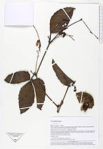
| Collector | Kvist, L.P. |
| Number | 790 |
| Collected with | Freitas,A. |
| Country | Peru |
| Subpart | Loreto |
| County | |
| Locality | Lower Ucayali river, approx. 6 km southwest of Jenaro Herrera village, along Aucayacu channal above the small community Nuevo Aucayacu |
| Coordinates | 4° 59' S 73° 42' W |
| Minimum elevation (m) | 120 |
| Maximum elevation (m) | 120 |
| Start date | 1994/01/15 |
| End date | 1994/01/15 |
| Family | Cucurbitaceae |
| Identification | Cayaponia amazonica (P. & E.)Cogn. |
| Determined by | M.Nee |
| Identification qualifier | |
| Field notes | Mostly exposed and disturbed vegetation along channal. Flooded up to several metres most of the year, predominatly by black water from local upland streams, but occasionally also by white water from the Ucayali river Climbing, flowers white, stamens yellow |
| |
 Other records of Cayaponia amazonica Other records of Cayaponia amazonicaThe map displays only records from the Aarhus Herbarium Database. The records may not represent the full distribution of Cayaponia amazonica |
| New Search Modify Search |