AAU Herbarium Database |
| New Search Modify Search |
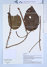
| Collector | Kvist, L.P. |
| Number | 682 |
| Collected with | L. Freitas A. |
| Country | Ecuador |
| Subpart | Loreto |
| County | |
| Locality | The lower Ucyayali river, approx. 6 km west of village Jenaro Herrera, "Zona de Supay". Channel between Ucayali river and Supay lake. Exposed vegetation along channal. Flooded most of the year, succeeding rising water levels in the Ucayal river predominantly flooded by white river, and succeeding heavy local rains predominantly by black water from local upland streams. |
| Coordinates | 4° 55' S 73° 45' W |
| Minimum elevation (m) | 120 |
| Maximum elevation (m) | 120 |
| Start date | 1993/11/20 |
| End date | 1993/11/20 |
| Family | Fabaceae |
| Identification | Dioclea |
| Determined by | G. P. Lewis (KEW) |
| Identification qualifier | |
| Field notes | Liana, erect inflorescences, white-violet corollas. |
| |
 Other records of Dioclea Other records of DiocleaThe map displays only records from the Aarhus Herbarium Database. The records may not represent the full distribution of Dioclea |
| New Search Modify Search |