AAU Herbarium Database |
| New Search Modify Search |
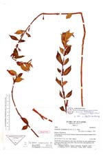
| Type of: | Columnea lavandulacea L.P. Kvist & L.E. Skog |
| Collector | Kvist, L. P. |
| Number | 49066 |
| Collected with | Barfod, A. |
| Country | Ecuador |
| Subpart | PICHINCHA |
| County | |
| Locality | Trail going from the new Santa Domingo-Quito road into disturbed montane forest on steep slopes. |
| Coordinates | 1° 21' S 78° 42' W |
| Minimum elevation (m) | 1700 |
| Maximum elevation (m) | 2000 |
| Start date | 1983/12/11 |
| End date | 1983/12/11 |
| Family | Gesneriaceae |
| Identification | Columnea katzensteinii (Wiehler)L. E. Skog & L. P. Kvist |
| Determined by | Skog, L.E. |
| Identification qualifier | |
| Field notes | HOLOTYPE. Herb, pendent on steep slope, leaf margin red, calyx purplish-green, corolla tube bluish-violet, limb yellow, lobes each with a dark purple dot at the base. (Photo: L. P. Kvist.). |
| |
| New Search Modify Search |