AAU Herbarium Database |
| New Search Modify Search |
| Collector | Kvist, L.P. |
| Number | 1473 |
| Collected with | |
| Country | Peru |
| Subpart | Loreto |
| County | |
| Locality | Along the lower Ucayali river, approx. 7 km west of the Jenaro Herrera, "Zona de Braga". In or near plot 2, 3 and 4 (of nine 100 x 100 metres large permanent plots). Plots located at large and fairly plain old natural levee maximally flooded a few months annually (restinga). Flooded by a mixture of black water from local upland streams and white water from the Ucayali river. |
| Coordinates | 4° 55' S 73° 45' W |
| Minimum elevation (m) | 120 |
| Maximum elevation (m) | 120 |
| Start date | 1995/03/21 |
| End date | 1995/03/21 |
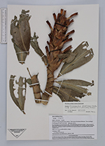
| Family | Zingiberaceae |
| Identification | Dimerocostus strobilaceus subsp. gutierrezii |
| Determined by | P.J.M.Maas, H.Maas |
| Identification qualifier | |
| Field notes | Herb, 1.5 m tall, corolla tubular, orange. |
| |
 Other records of Dimerocostus strobilaceus subsp. gutierrezii Other records of Dimerocostus strobilaceus subsp. gutierreziiThe map displays only records from the Aarhus Herbarium Database. The records may not represent the full distribution of Dimerocostus strobilaceus subsp. gutierrezii |
| New Search Modify Search |