AAU Herbarium Database |
| New Search Modify Search |
| Collector | Kvist, L.P. |
| Number | 1360 |
| Collected with | H.Christensen |
| Country | Peru |
| Subpart | Loreto |
| County | |
| Locality | Along the lower Ucayali river, approx. 7 km west of the Genaro Herrera village, "Zona de Braga". Research area where permanent plots 1-4 and 8-9 are located. Mostly natural levees. Maximally flooded a few months annually (restinga), but traversed by several metres lower areas (bajiales) often inundated more than a half year annually. Flooded by a mixture of white water from the Ucayali river and black water from local upland streams. |
| Coordinates | 4° 55' S 73° 45' W |
| Minimum elevation (m) | 120 |
| Maximum elevation (m) | 120 |
| Start date | 1994/11/14 |
| End date | 1994/11/16 |
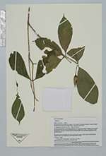
| Family | Solanaceae |
| Identification | Markea formicarum Dammer |
| Determined by | Anders Orejuela (E) |
| Identification qualifier | |
| Field notes | Epiphytic, roots associated with ants, calyces pale green, corolla tube creamish-green outside, limb with violet lines, tube bright yellow inside. |
| |
 Other records of Markea formicarum Other records of Markea formicarumThe map displays only records from the Aarhus Herbarium Database. The records may not represent the full distribution of Markea formicarum |
| New Search Modify Search |