AAU Herbarium Database |
| New Search Modify Search |
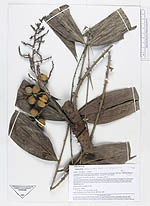
| Collector | Kvist, L.P. |
| Number | 1196 |
| Collected with | |
| Country | Peru |
| Subpart | Loreto |
| County | |
| Locality | Along the lower Ucayali river, approx. 7 km west of the Jenaro Herrera, "Zona de Braga". Research area where permanent plots 1-4 and 8-9 are located. |
| Coordinates | 4° 55' S 73° 45' W |
| Minimum elevation (m) | 120 |
| Maximum elevation (m) | 120 |
| Start date | 1994/09/29 |
| End date | 1994/09/30 |
| Family | Arecaceae |
| Identification | Desmoncus polyacanthos Mart. |
| Determined by | A. Henderson |
| Identification qualifier | |
| Field notes | Mostly natural leaves, maximally flooded a few months annually (restinga), but traversed by several metres lower areas (baijales) often inundated more than a half year annually. Flooded by a mixture of white water from the Ucayali river and black water from local upland streams. Liana, fruits raddish-violet. |
| |
| Display all 53 georeferenced records of Desmoncus Desmoncus polyacanthos |
| New Search Modify Search |