| Collector | Kvist, L. P. |
| Number | 1002 |
| Collected with | L. Freitas A. |
| Country | Peru |
| Subpart | Loreto |
| County | |
| Locality | Along the lower Ucayali river, approx. 7 km west of the Jenaro Herrera village, "Zona de Braga". Research area where permanent plots 1-4 and 8-9 are located. |
| Coordinates | 4° 55' S 73° 45' W |
| Minimum elevation (m) | 120 |
| Maximum elevation (m) | 120 |
| Start date | 1993/12/01 |
| End date | 1993/12/20 |
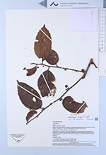
| Family | Dilleniaceae |
| Identification | Doliocarpus major J. F. Gmel. |
| Determined by | Monzoli, J.V.L. |
| Identification qualifier | |
| Field notes | Collected in or near plot 8. Maximally flooded a few months annually (restinga), but traversed by several metres lower areas (bajiales) often inundated a half year annually. Flo'oded by a mixture of white water from the Ucayali river and black water from local upland streams. Climbing. |
|
 Other records of Doliocarpus major