AAU Herbarium Database |
| New Search Modify Search |
| Collector | Dorr, L.J. |
| Number | 7240 |
| Collected with | Barnett, L. C.; Diaz, W. |
| Country | Venezuela |
| Subpart | |
| County | |
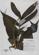
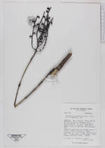
| Locality | Edo. Trujillo. Distr. Boconó. Montanas de Misisí, carretera vieja Trujillo-Boconó,ca. 12 km by air NW of Boconó. Montane forest at and above the "Cecropia" belt. |
| Coordinates | 9° 21' N 70° 18' W |
| Minimum elevation (m) | 2000 |
| Maximum elevation (m) | 2400 |
| Start date | 1990/07/04 |
| End date | 1990/07/04 |
| Family | Arecaceae |
| Identification | Chamaedorea pinnatifrons (Jacq.)Oerst. |
| Determined by | Henderson, A. |
| Identification qualifier | |
| Field notes | Understory palm with very slender stems to 2 m tall. Leaves clustered at summit, ascending, ca 1-1,5 m long. Inflorescences erect, 3-4 per plant, at leaf nodes. Fruit orange, maturing to black. |
| |
| Display all 228 georeferenced records of Chamaedorea Chamaedorea pinnatifrons |
| New Search Modify Search |