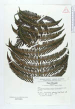
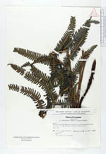
| Collector | Holm-Nielsen, L. B. |
| Number | 4655 |
| Collected with | Jeppesen, S. & Lojtnant, B. & Ollgaard, B. |
| Country | Ecuador |
| Subpart | LOJA |
| County | |
| Locality | Km 51 on Pan American Highway N of Loja. Shrub, 2-4 m high, dominated by xerophytic vegetation, on steep roadsides. |
| Coordinates | 3° 45' S 79° 15' W |
| Minimum elevation (m) | 2900 |
| Maximum elevation (m) | 2900 |
| Start date | 1973/05/01 |
| End date | 1973/05/01 |
| Family | Thelypteridaceae |
| Identification | Thelypteris retrorsa (Sodiro)A. R. Sm. |
| Determined by | A. R. Smith (UC), 1979. |
| Identification qualifier | |
| Field notes | In shade by stream. |
|
 Other records of Thelypteris retrorsa