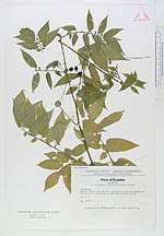
| Collector | Holm-Nielsen, L. B. |
| Number | 3167 |
| Collected with | Jeppesen, S. & Lojtnant, B. & Ollgaard, B. |
| Country | Ecuador |
| Subpart | COTOPAXI |
| County | |
| Locality | Quevedo - Latacunga road. Steep rocky slopes along Río Pilaló with scattered trees. Subtropical rain forest on fat clay. |
| Coordinates | 0° 52' S 79° 9' W |
| Minimum elevation (m) | 1200 |
| Maximum elevation (m) | 1300 |
| Start date | 1973/04/07 |
| End date | 1973/04/07 |
| Family | Solanaceae |
| Identification | Solanum suaveolens Kunth & Bouché |
| Determined by | Sandra Knapp & David M. Spooner |
| Identification qualifier | |
| Field notes | Leaning on other herbs at the roadside. |
|
 Other records of Solanum suaveolens