| Collector | Holm-Nielsen, L. B. |
| Number | 28663 |
| Collected with | Jaramillo, J. |
| Country | Ecuador |
| Subpart | TUNGURAHUA |
| County | |
| Locality | Cordillera de los Llanganates. Loma 2.5 km W of Cerro Hermoso. Polylepis forest. |
| Coordinates | 1° 13' S 78° 18' W |
| Minimum elevation (m) | 3800 |
| Maximum elevation (m) | 3800 |
| Start date | 1980/11/12 |
| End date | 1980/11/12 |
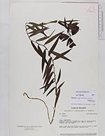
| Family | Alstroemeriaceae |
| Identification | Bomarea uncifolia Herb. |
| Determined by | Harling, G. (GB), 2003; Hofreiter (MSB) 2007 |
| Identification qualifier | |
| Field notes | Sepals pale red with bluish tip. Petals yellow at base. Vein pink, broad part green. Anthers blue. |
|
 Other records of Bomarea uncifolia