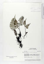
| Collector | Holm-Nielsen, L. B. |
| Number | 16167 |
| Collected with | |
| Country | Ecuador |
| Subpart | PICHINCHA |
| County | |
| Locality | Road San Antonio - Calacalí - Nanegal, 20 km W of Calacalí. Pastures and shrub forests on rocky slopes. Cloud forest area. |
| Coordinates | 0° 1' N 78° 34' W |
| Minimum elevation (m) | 2700 |
| Maximum elevation (m) | 2700 |
| Start date | 1979/03/25 |
| End date | 1979/03/25 |
| Family | Polypodiaceae |
| Identification | Polypodium segregatum Baker |
| Determined by | B. Ollgaard, 1983 |
| Identification qualifier | |
| Field notes | Epiphyte in montane forest. |
|
 Other records of Polypodium segregatum