AAU Herbarium Database |
| New Search Modify Search |
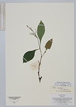
| Collector | Averyanov, L. |
| Number | VH4968 |
| Collected with | N.T. Hiep |
| Country | Vietnam |
| Subpart | Cao Bang |
| County | |
| Locality | Distr. Tra Linh, municipalite Quoc Toan, vicinity of Thang Heng and Lung Tao villages near Thang Heng lake. Closed evergreen broadleaved primary forest on steep slopes and bluffs of limestone ridges and mesas. |
| Coordinates | |
| Minimum elevation (m) | 600 |
| Maximum elevation (m) | 650 |
| Start date | 1997/05/25 |
| End date | 1997/05/27 |
| Family | Acanthaceae |
| Identification | Justicia kampotiana Benoist |
| Determined by | Deng Yunfei |
| Identification qualifier | |
| Field notes | Shrublet up to 1.5 m hg in wet open place. Not common. |
| |
| This record has no coordinates. Display map with the 3 georeferenced records of Justicia kampotiana in the AAU Herbarium Database. |
| New Search Modify Search |