AAU Herbarium Database |
| New Search Modify Search |
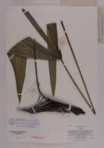
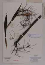
| Collector | Averyanov, L. |
| Number | VH4915 |
| Collected with | N.T. Hiep |
| Country | Vietnam |
| Subpart | N. Vietnam |
| County | |
| Locality | Prov. Cao Bang, distr. Tra Linh, municipality Quoc Toan, vicinity of Thang Heng and Lung Tao villages near Thang Heng lake. Open dry primary mixed forest with domination og Keteleeria fortunei on top of limestone mesas and ridges |
| Coordinates | |
| Minimum elevation (m) | 650 |
| Maximum elevation (m) | 900 |
| Start date | 1997/05/25 |
| End date | 1997/05/27 |
| Family | Arecaceae |
| Identification | Guihaia grossifibrosa (Gagnep)J.Dransf. |
| Determined by | A. Henderson |
| Identification qualifier | |
| Field notes | Palm up to 3 m high in open dry forest and on open rocks and bluffs. Very common. Usual codominante of 3 forest stratum on tops of ridges and mesas at 800-1000 m alt |
| |
| This record has no coordinates. Display map with the 2 georeferenced records of Guihaia grossifibrosa in the AAU Herbarium Database. |
| New Search Modify Search |