AAU Herbarium Database |
| New Search Modify Search |
| Collector | Averyanov, L. |
| Number | VH4851 |
| Collected with | N. T. Hiep |
| Country | Vietnam |
| Subpart | Cao Bang |
| County | |
| Locality | Tra Linh, Quoc Toan, vicinity of Thang Heng and Lung Tao villages near Thang Heng lake. |
| Coordinates | |
| Minimum elevation (m) | 500 |
| Maximum elevation (m) | 500 |
| Start date | 1997/05/25 |
| End date | 1997/05/27 |
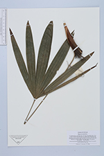
| Family | Arecaceae |
| Identification | Rhapis micrantha Becc. |
| Determined by | |
| Identification qualifier | |
| Field notes | Remnant closed evergreen primary broadleaved forest in alluvial valley bottom between limestone ridges and mesas near karst lake. Palm up to 2 m hg in shadow rocky lake slopes. Not common |
| |
| This record has no coordinates. Display map with the 2 georeferenced records of Rhapis micrantha in the AAU Herbarium Database. |
| New Search Modify Search |