AAU Herbarium Database |
| New Search Modify Search |
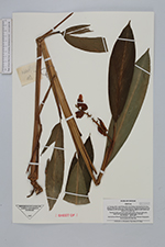
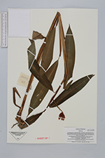
| Collector | Averyanov, L. |
| Number | VH4414 |
| Collected with | N.Q.Binh, N.T.Hiep |
| Country | Vietnam |
| Subpart | Lam Dong |
| County | |
| Locality | Distr. Lac Duong, municipalite Da Chay, 40 km to NE from Dalact city. Closed primary evergreen broadleaved wet mt forest on SW macroslope of Hong Giao mt ridge. |
| Coordinates | 12° 11' N 108° 43' E |
| Minimum elevation (m) | 1500 |
| Maximum elevation (m) | 1650 |
| Start date | 1997/04/26 |
| End date | 1997/04/26 |
| Family | Zingiberaceae |
| Identification | Alpinia |
| Determined by | |
| Identification qualifier | |
| Field notes | Terrestial herb up to 0.8 m hg in open place. Flowers light pink, seplas and central petal with purple base. Not rare. |
| |
| Display all 35 georeferenced records of Alpinia Alpinia |
| New Search Modify Search |