AAU Herbarium Database |
| New Search Modify Search |
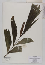
| Collector | Averyanov, L. |
| Number | VH3588 |
| Collected with | N.Q. Binh & P.K. Loc |
| Country | Vietnam |
| Subpart | Ninh Thuan |
| County | |
| Locality | S.Vietnam. Prov. Ninh Thuan, distr. Ninh Son, municipalite Phuoc Binh in 34 km to NE from Dalat city. Closed primary broadleaved forest along mt ridge between Bi Dup and Gia Rinh mt. |
| Coordinates | 12° 7' N 108° 42' E |
| Minimum elevation (m) | 1800 |
| Maximum elevation (m) | 1900 |
| Start date | 1997/04/03 |
| End date | 1997/04/03 |
| Family | Arecaceae |
| Identification | Caryota |
| Determined by | |
| Identification qualifier | |
| Field notes | Palm up to 10 m hg with leaves about 5 m lg in deep wet stream canyon. Not common |
| |
 Other records of Caryota Other records of CaryotaThe map displays only records from the Aarhus Herbarium Database. The records may not represent the full distribution of Caryota |
| New Search Modify Search |